Notifications
ALL BUSINESS
COMIDA
DIRECTORIES
ENTERTAINMENT
FINER THINGS
HEALTH
MARKETPLACE
MEMBER's ONLY
MONEY MATTER$
MOTIVATIONAL
NEWS & WEATHER
TECHNOLOGIA
TV NETWORKS
VIDEOS
VOTE USA 2026/2028
INVESTOR RELATIONS
COMING 2026 / 2027
ALL BUSINESS
COMIDA
DIRECTORIES
ENTERTAINMENT
FINER THINGS
HEALTH
MARKETPLACE
MEMBER's ONLY
MONEY MATTER$
MOTIVATIONAL
NEWS & WEATHER
TECHNOLOGIA
TV NETWORKS
VIDEOS
VOTE USA 2026/2028
INVESTOR RELATIONS
COMING 2026 / 2027
About Me
 Latinos Media
 Latinos Media provides all types of news feeds on a daily basis to our Members
Posted by - Latinos Media -
on - December 26, 2023 -
Filed in - Weather -
-
771 Views - 0 Comments - 0 Likes - 0 Reviews

ALL forecasts herein are the result of my analysis, (to which you will see me at times, insert excerpts from various agencies due to the nature of the importance of the information) and I am solely responsible for the content. As ALWAYS, follow the National Hurricane Center, National Weather Service, and your local Emergency Management officials for emergency decisions. In addition, this is strictly a FORECAST OFFICE. I CANNOT make decisions regarding travel plans, etc. My purpose, is to provide you the information, based solely on information I analyze, and the accuracy of the information at hand of the time of analysis, so you may make informed decisions.
(T. F. “Storm” Walsh)
For those who have donated to my site, your help has been greatly appreciated. If you are not aware, donations to my site help pay for subscriptions to sites I use as well as software updates, which provide all the models and information used in my forecasts. To donate, please click the DONATE button to the right side of the page, or on the graphic of the dog. Any help you provide is immensely appreciated!
DONATIONS ACCEPTED AND APPRECIATED


If any of my subscribers here are on Facebook, and are in any of the weather groups I posted in, please let everyone know that Facebook suspended my old account. Since I may not be able to access Facebook anymore, you may follow me on twitter. The twitter button on the left of the page does not work. Please follow me here: https://twitter.com/Michael1227910
If you wish to become an email client and receive my forecasts by email, please send me an email at the email address at the bottom of the page…subject: EMAIL CLIENT.
I will reiterate, my forecasts are based on the available information at the time of analysis, and are only as accurate as the information analyzed and the solutions provided. Keep in mind, if a forecast doesn’t exactly pan out, remember, the atmosphere is fluid in motion. When models are being analyzed, that’s just one run, and I have to go with what is presented. After that, models don’t update again for another 4 – 6 hours, so, what happens between that time is unknown, and forecast conditions can change slightly, to greatly. This will have an effect on my actual forecast. Unless otherwise noted, satellite imagery is provided through Weathernerds.org
Greetings everyone!
I will be taking some more time off for the holiday, and plan on resuming forecasts on Jan. 01, 2024.
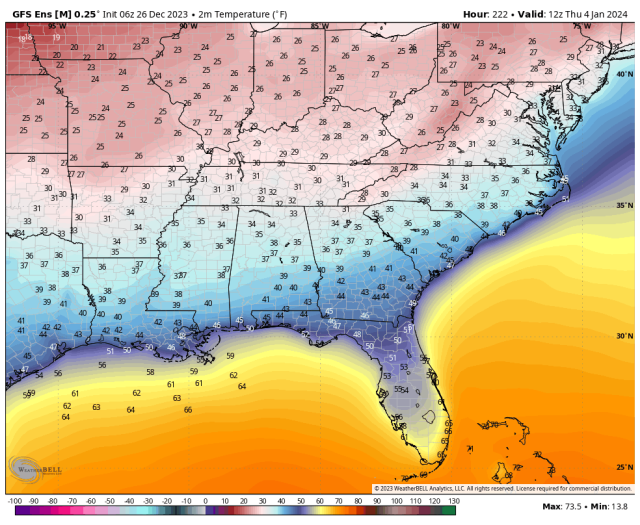
Pulling up models this morning, there are only slight changes in the ongoing and upcoming pattern over the next 72 hours, and was discussed in my previous update on Dec 21. There is no threat as of yet for severe weather during this week, as per the Storm Prediction Center. I did however want to briefly touch on another phenomenon. From Jan. 01 – Jan. 08, a SSW (Sudden Stratospheric Warming) event is forecast to reload. This COULD be a major SSW event, as temperatures at 10m are forecast to increase by a little over 50C in a 6 day period. At the moment, it is unknown if this will disrupt the Polar Vortex enough to allow Arctic air to plunge southward over the U. S. Currently, forecast temperature maps do indicate a majority of the U. S. will experience freezing, to below freezing minimum temperatures on the morning of Jan. 04.
I will be monitoring this during my time off, and will update on this, and any significant winter weather that may be in the works after this week. As always, if a threat for severe weather does make its way into the forecast, I will have an update for you.
The following graphics indicate the temperature and height anomalies at 10 mb for the time period shown by the models:
ECMWF AND GEFS 10 MB TEMPERATURE ANOMALIES FORECAST

ECMWF AND GEFS 10 MB HEIGHT ANOMALIES FORECAST

ECMWF AND GEFS MINIMUM TEMPERATURE FORECAST FOR JAN. 04, 2024


SSW AND POLAR VORTEX ARTICLE FROM WIKIPEDIA
https://en.wikipedia.org/wiki/Sudden_stratospheric_warming
https://en.wikipedia.org/wiki/Polar_vortex
The following NWS Watch / Warning map will provide local NWS information for your area. Click the image, then once it refreshes, click on your area of interest to view any special weather statements, hazards or advisories for your area.
NWS WATCH / WARNING DISPLAY (LINKED…CLICK MAP, THEN YOUR AREA)
NWS DOPPLER RADAR LOOP (LINKED, CLICK RADAR MAP)
RAP RADAR (CLICK IMAGE THEN RADAR SITE…ONCE YOU CLICK THE SITE, GO TO LOOP DURATION TO CREATE A LOOP)
CARIBBEAN RADAR (CLICK IMAGE)
You may direct any questions by contacting me personally, ANYTIME, at: twalsh22000@yahoo.com
Have a blessed day!
T. F. “STORM” WALSH III
GMCS, USCG (ret)
METEOROLOGIST / HURRICANE SPECIALIST /SEVERE WEATHER SPECIALIST