Notifications
ALL BUSINESS
COMIDA
DIRECTORIES
ENTERTAINMENT
FINER THINGS
HEALTH
MARKETPLACE
MEMBER's ONLY
MONEY MATTER$
MOTIVATIONAL
NEWS & WEATHER
TECHNOLOGIA
TV NETWORKS
VIDEOS
VOTE USA 2026/2028
INVESTOR RELATIONS
COMING 2026 / 2027
ALL BUSINESS
COMIDA
DIRECTORIES
ENTERTAINMENT
FINER THINGS
HEALTH
MARKETPLACE
MEMBER's ONLY
MONEY MATTER$
MOTIVATIONAL
NEWS & WEATHER
TECHNOLOGIA
TV NETWORKS
VIDEOS
VOTE USA 2026/2028
INVESTOR RELATIONS
COMING 2026 / 2027
About Me
 Latinos Media
 Latinos Media provides all types of news feeds on a daily basis to our Members
Posted by - Latinos Media -
on - May 16, 2023 -
Filed in - Weather -
-
0.9K Views - 0 Comments - 0 Likes - 0 Reviews

Disclaimer: This is not affiliated with the National Hurricane Center, Hurricane Hunters, Storm Prediction Center, or National Weather Service. ALL forecasts herein are the result of my analysis, (to which you will see me at times, insert excerpts from various agencies due to the nature of the importance of the information) and I am solely responsible for the content. As ALWAYS, follow the National Hurricane Center, National Weather Service, and your local Emergency Management officials for emergency decisions. In addition, this is strictly a FORECAST OFFICE. I CANNOT make decisions regarding travel plans, etc. My purpose, is to provide you the information, based solely on information I analyze, and the accuracy of the information at hand of the time of analysis, so you may make informed decisions.
(T. F. “Storm” Walsh)
For those who have donated to my site, your help has been greatly appreciated. If you are not aware, donations to my site help pay for subscriptions to sites I use as well as software updates, which provide all the models and information used in my forecasts. To donate, please click the DONATE button to the right side of the page, or on the graphic of the dog. Any help you provide is immensely appreciated!
DONATIONS ACCEPTED AND APPRECIATED

I will reiterate, my forecasts are based on the available information at the time of analysis, and are only as accurate as the information analyzed and the solutions provided.
Good evening!
The following is my outlook forecast for the upcoming 2023 Atlantic Hurricane Season. These totals are based on changes to some of the updated climate model data.
STORM W PRE-SEASON FORECAST
TOTAL NAMED STORMS: 11– 14
TOTAL HURRICANES : 5 – 6
MAJOR HURRICANES: 2 – 3
AVERAGE HURRICANE SEASON:
TOTAL NAMED STORMS: 14
TOTAL HURRICANES: 7
MAJOR HURRICANES: 3
The following are the storm names for the 2023 hurricane season. As each storm is named, they will be colored in red in order to keep track of the used names in the list:
Arlene Bret Cindy Don Emily Franklin Gert Harold Idalia Jose Katia
Lee Margot Nigel Ophelia Philippe Rina Sean Tammy Vince Whitney
Today began the issuance of the NHC Tropical Weather Outlook. From the NHC:
Tropical Weather Outlook
NWS National Hurricane Center Miami FL
800 AM EDT Mon May 15 2023

For the North Atlantic...Caribbean Sea and the Gulf of Mexico:

Tropical cyclone formation is not expected during the next 7 days.

Today, May 15th, marks the first day of routine issuance of the
Atlantic basin Tropical Weather Outlook in 2023.  This product
describes significant areas of disturbed weather and their
potential for tropical cyclone formation during the next seven
days.  The Tropical Weather Outlook is issued from May 15 through
November 30 each year.  The issuance times of this product are 2
AM, 8 AM, 2 PM, and 8 PM EDT.  After the change to standard time
in November, the issuance times are 1 AM, 7 AM, 1 PM, and 7 PM EST.

A Special Tropical Weather Outlook will be issued to provide
updates, as necessary, in between the regularly scheduled issuance's
of the Tropical Weather Outlook.  Special Tropical Weather Outlooks
will be issued under the same WMO and AWIPS headers as the regular
Tropical Weather Outlooks.

A graphical version of the Tropical Weather Outlook is available on
the web at: https://www.hurricanes.gov.

$
Forecaster Kelly/Cangialosi
Based on my analysis this evening of the various global models and ensembles, Tropical Storm formation is not expected during the next 7 days. Although the ECMWF EPS Cyclone Formation Probability model indicates a very low (15%) probability off of the Carolinas in the next 72-120 hours, this appears to be in relationship to an extremely small lower pressure anomaly. I am not expecting anything to become of this right now, as the shear and upper level wind pattern is forecast to remain unfavorable.
ECMWF EPS CYCLONE FORMATION PROBABILITY
The NHC analyzed a tropical wave in the far eastern Atlantic getting ready to exit the African continent:
NHC TAFB 18Z SURFACE ANALYSIS
WEATHERNERDS AFRICASAT
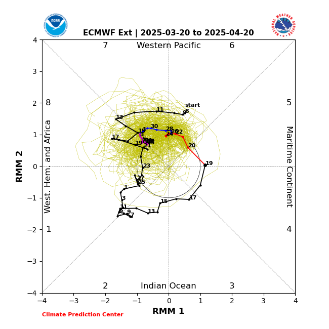
In the extended range, there could be tropical mischief as we get closer to Memorial day, beginning around the 25th of May, onward. Based on analysis of the current MJO forecast phase space diagrams, the BOM (Bureau Of Meteorology) And Canadian modeling indicate the MJO to enter Phase 8, then into Phase 1. Thus far, the BOM modeling has been the most accurate at handling the MJO pattern. The ECMWF Ens. has been slowly edging toward this solution of Phase 8 during the past week. Previously, the model brought the MJO to Phase 7, then crashed it into the “null” phase.
BOM MJO FORECAST
CANADIAN
ECMWF EPS
The ECMWF EPS CHI 200 anomalies mean forecast indicates upward motion (favorable) on our side of the world, as well as the JMA model showing upward motion (blue shading) as well.
ECMWF CHI 200 ANOMALIES (MEAN) FORECAST
JMA WEEK 3 AND 4
During this same period, Deterministic and Ensemble modeling (mainly the Ensembles), indicate a lowering of MSLP Normalized anomalies IVO Florida and the Bahamas. Note that dates vary with each model:
MSLP NORMALIZED ANOMALIES FORECAST VARIOUS MODELS:


