ALL forecasts herein are the result of my analysis, (to which you will see me at times, insert excerpts from various agencies due to the nature of the importance of the information) and I am solely responsible for the content. As ALWAYS, follow the National Hurricane Center, National Weather Service, and your local Emergency Management officials for emergency decisions. In addition, this is strictly a FORECAST OFFICE. I CANNOT make decisions regarding travel plans, etc. My purpose, is to provide you the information, based solely on information I analyze, and the accuracy of the information at hand of the time of analysis, so you may make informed decisions.
(T. F. “Storm” Walsh)
For those who have donated to my site, your help has been greatly appreciated. If you are not aware, donations to my site help pay for subscriptions to sites I use as well as software updates, which provide all the models and information used in my forecasts. To donate, please click the DONATE button to the right side of the page, or on the graphic of the dog. Any help you provide is immensely appreciated!
DONATIONS ACCEPTED AND APPRECIATED


If any of my subscribers here are on Facebook, and are in any of the weather groups I posted in, please let everyone know that Facebook suspended my old account. Since I may not be able to access Facebook anymore, you may follow me on twitter. The twitter button on the left of the page does not work. Please follow me here: https://twitter.com/Michael1227910
If you wish to become an email client and receive my forecasts by email, please send me an email at the email address at the bottom of the page…subject: EMAIL CLIENT.
I will reiterate, my forecasts are based on the available information at the time of analysis, and are only as accurate as the information analyzed and the solutions provided. Keep in mind, if a forecast doesn’t exactly pan out, remember, the atmosphere is fluid in motion. When models are being analyzed, that’s just one run, and I have to go with what is presented. After that, models don’t update again for another 4 – 6 hours, so, what happens between that time is unknown, and forecast conditions can change slightly, to greatly. This will have an effect on my actual forecast. Unless otherwise noted, satellite imagery is provided through Weathernerds.org
The following is my outlook forecast for the 2023 Atlantic Hurricane Season:
STORM W SEASONAL FORECAST
TOTAL NAMED STORMS: 14– 16
TOTAL HURRICANES : 5 – 7
MAJOR HURRICANES: 3 – 4
AVERAGE HURRICANE SEASON:
TOTAL NAMED STORMS: 14
TOTAL HURRICANES: 7
MAJOR HURRICANES: 3
SEASON TOTALS:
NAMED STORMS: 16
HURRICANES: 6
MAJOR HURRICANES: 3
Given that the NHC has named at least 3, if not more, garbage systems, I had to increase my seasonal forecast slightly.
The following are the storm names for the 2023 hurricane season. As each storm is named, they will be colored in red in order to keep track of the used names in the list:
Arlene Bret Cindy Don Emily Franklin Gert Harold Idalia Jose Katia
Lee Margot Nigel Ophelia Philippe Rina Sean Tammy Vince Whitney
Greetings everyone!
As a reminder, when forecasting tropical systems, if there are numerous systems to deal with, I always update on the systems that may present an impact or threat to either the U. S. or the Caribbean islands. Anything far out in the Atlantic or something that may re-curve, take a lower priority as there is more time to deal with them. Unless we have a system threatening any area, the forecast office will be closed on the weekends.
Earlier this morning, a large area of concentrated heavy convection was noted south of Cuba, an MCS (Mesoscale Convective System) if you will, heading north. This has since come in over Cuba and has deteriorated. However, the tropical wave associated with it appears to have taken a trek on a northward motion. Though it may be heading north, I do not believe development will occur. I will continue to monitor this to see where it winds up, given the current and forecast pattern.

 Satellite loop imagery this afternoon indicates the center of Tropical Storm PHILIPPE is totally exposed to the west of the heavy convection. This can be attributed to the system still being under the effect of wind shear. Although a nice outflow seems present, without the LLC under the convection, the upper level outflow will not offset the shear effect.. In my analysis of the wind shear forecast maps from both the GFS and ECMWF, wind shear is forecast to remain present through the forecast period, and is confirmed by the recent SHIPS diagnostics. Based on this analysis. The storm is also forecast to run into a drier surface to mid level environment. Based on this analysis, PHILIPPE should continue to gradually weaken. While I agree with the NHC intensity forecast, I believe with the LLC exposed, weakening may occur in a little quicker trend. Regardless, the system should dissipate within the next 5 days.
PHILIPPE CIMSS WIND SHEAR AND UPPER LEVEL WINDS


NHC INTENSITY FORECAST
INIT  26/2100Z 17.1N  51.3W   40 KT  45 MPH
 12H  27/0600Z 17.3N  52.7W   40 KT  45 MPH
 24H  27/1800Z 18.4N  54.5W   35 KT  40 MPH
 36H  28/0600Z 19.2N  56.1W   35 KT  40 MPH
 48H  28/1800Z 19.7N  57.9W   35 KT  40 MPH
 60H  29/0600Z 20.0N  59.3W   30 KT  35 MPH
 72H  29/1800Z 20.1N  61.0W   30 KT  35 MPH
 96H  30/1800Z 20.2N  64.0W   25 KT  30 MPH...POST-TROP/REMNT LOW
120H  01/1800Z 20.3N  67.8W   25 KT  30 MPH...POST-TROP/REMNT LOW
As of 5:00 p.m. EDT, the following information was available on PHILIPPE from the NHC:
5:00 PM AST Tue Sep 26
Location: 17.1°N 51.3°W
Moving: W at 13 mph
Min pressure: 1003 mb / 29.62 in
Max sustained: 45 mph
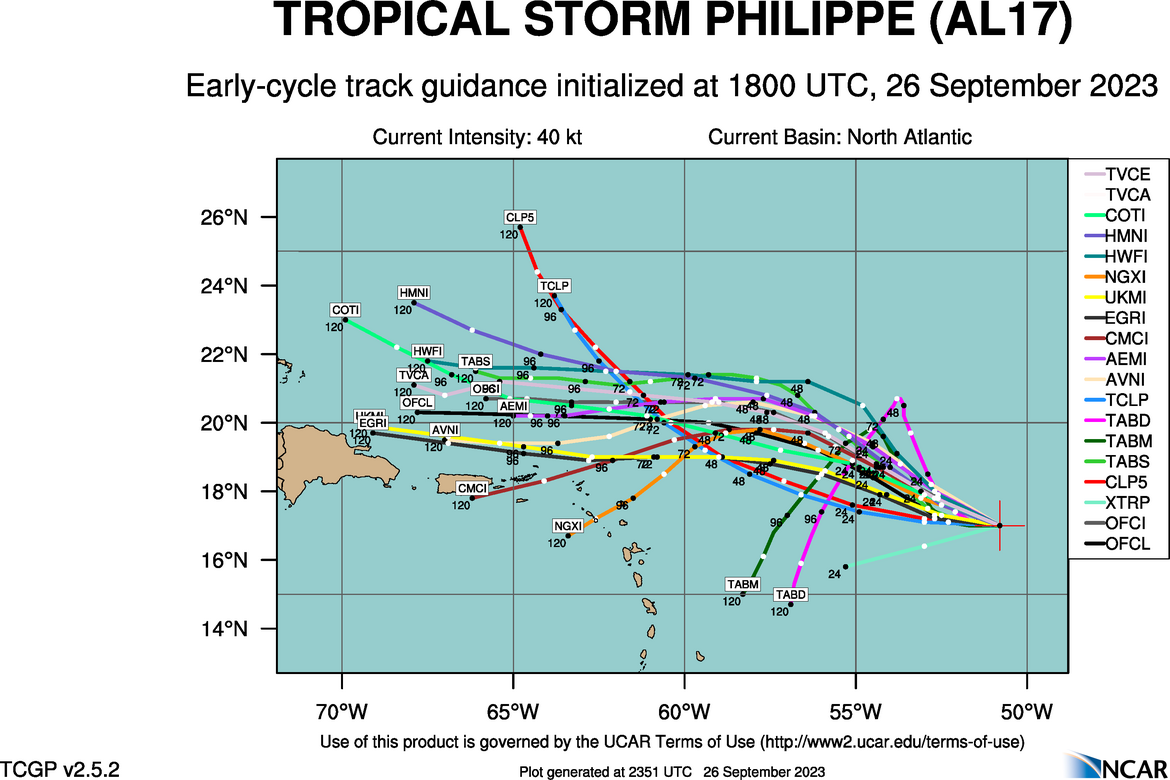
There has been a major change in track guidance and the NHC forecast track. PHILIPPE is now moving toward the west. Based on current and forecast steering analysis, since the LLC is exposed, a westward motion should continue for the remainder of the forecast period, with a slight jog to the WNW briefly and then west, due to forecast fluctuations in the steering flow. Given we’ll be following the LLC vice the convection, PHILIPPE will be steered by the low level steering mean. The feature on the right with the red and yellow wind speed color is 91L. Based on this, the 18Z guidance looks good.
GFS 850 – 700 MB STEERING FORECAST

 18Z ATCF GUIDANCE
 NHC FORECAST TRACK

I’ll continue to monitor PHILIPPE for any changes to the forecast and up until dissipation.
INVEST 91L continues to become slowly better organized. As of 2:00 p.m. EDT, the following information was available on INVEST 91L from the ATCF BTK update:
2:00 PM AST Tue Sep 26
Location: 11.2°N 39.2°W
Moving:WNW at 20 mph
Min pressure: 1008 mb / 29.77 in
Max sustained: 35 mph
Based on analysis of satellite loop imagery, although co-ordinates indicate 11.2N, there appears to be another circulation to the SE of that location seen in visible imagery. Based on this, there could be a center reformation that may occur, however will remain to be seen.


91L is under a little bit of shear as well, however it appears the system has an impressive upper outflow pattern beginning to develop. It is noted the 200 mb pattern has improved immensely from this morning.
CIMSS 91L WIND SHEAR AND UPPER LEVEL WINDS


Based on my analysis of the various forecast parameters for moisture, shear, 200 mb streamlines, the current projection is, conditions may wax and wane as far as favorability, and in general, may remain a little less than favorable, though if that outflow pattern holds, shear should be offset. So it appears during this first 5 – 7 day period from 12Z, this system may gradually intensify. From this point, we should consider this low confidence being past day 7. However, by day 9 – 10, around Oct. 5, conditions are forecast to improve dramatically with a very established radial shear pattern over the system, 200 mb radial outflow, high PWAT and 500 mb RH values, in a symmetric pattern. This is forecast to occur around the time the system is supposedly north of the Caribbean islands. Given the moderate to high OHC in the path, SHOULD this occur, we could see another very steady to rapid intensification occur. Maximum sustained winds were 35 mph. Should the center become better defined, I would expect 91L to be upgraded to a tropical depression at any time.
ECMWF FORECAST CONDITIONS 222 HOURS FROM 12Z
![]()


 Satellite loop imagery this afternoon indicates the center of Tropical Storm PHILIPPE is totally exposed to the west of the heavy convection. This can be attributed to the system still being under the effect of wind shear. Although a nice outflow seems present, without the LLC under the convection, the upper level outflow will not offset the shear effect.. In my analysis of the wind shear forecast maps from both the GFS and ECMWF, wind shear is forecast to remain present through the forecast period, and is confirmed by the recent SHIPS diagnostics. Based on this analysis. The storm is also forecast to run into a drier surface to mid level environment. Based on this analysis, PHILIPPE should continue to gradually weaken. While I agree with the NHC intensity forecast, I believe with the LLC exposed, weakening may occur in a little quicker trend. Regardless, the system should dissipate within the next 5 days.


 18Z ATCF GUIDANCE
 NHC FORECAST TRACK


