ALL forecasts herein are the result of my analysis, (to which you will see me at times, insert excerpts from various agencies due to the nature of the importance of the information) and I am solely responsible for the content. As ALWAYS, follow the National Hurricane Center, National Weather Service, and your local Emergency Management officials for emergency decisions. In addition, this is strictly a FORECAST OFFICE. I CANNOT make decisions regarding travel plans, etc. My purpose, is to provide you the information, based solely on information I analyze, and the accuracy of the information at hand of the time of analysis, so you may make informed decisions.
(T. F. “Storm” Walsh)
For those who have donated to my site, your help has been greatly appreciated. If you are not aware, donations to my site help pay for subscriptions to sites I use as well as software updates, which provide all the models and information used in my forecasts. To donate, please click the DONATE button to the right side of the page, or on the graphic of the dog. Any help you provide is immensely appreciated!
DONATIONS ACCEPTED AND APPRECIATED


If any of my subscribers here are on Facebook, and are in any of the weather groups I posted in, please let everyone know that Facebook suspended my old account. Since I may not be able to access Facebook anymore, you may follow me on twitter. The twitter button on the left of the page does not work. Please follow me here: https://twitter.com/Michael1227910
If you wish to become an email client and receive my forecasts by email, please send me an email at the email address at the bottom of the page…subject: EMAIL CLIENT.
I will reiterate, my forecasts are based on the available information at the time of analysis, and are only as accurate as the information analyzed and the solutions provided. Keep in mind, if a forecast doesn’t exactly pan out, remember, the atmosphere is fluid in motion. When models are being analyzed, that’s just one run, and I have to go with what is presented. After that, models don’t update again for another 4 – 6 hours, so, what happens between that time is unknown, and forecast conditions can change slightly, to greatly. This will have an effect on my actual forecast. Unless otherwise noted, satellite imagery is provided through Weathernerds.org
The following is my outlook forecast for the 2023 Atlantic Hurricane Season:
STORM W SEASONAL FORECAST
TOTAL NAMED STORMS: 14– 16
TOTAL HURRICANES : 5 – 7
MAJOR HURRICANES: 3 – 4
AVERAGE HURRICANE SEASON:
TOTAL NAMED STORMS: 14
TOTAL HURRICANES: 7
MAJOR HURRICANES: 3
SEASON TOTALS:
NAMED STORMS: 17
HURRICANES: 6
MAJOR HURRICANES: 3
Given that the NHC has named at least 3, if not more, garbage systems, I had to increase my seasonal forecast slightly.
The following are the storm names for the 2023 hurricane season. As each storm is named, they will be colored in red in order to keep track of the used names in the list:
Arlene Bret Cindy Don Emily Franklin Gert Harold Idalia Jose Katia
Lee Margot Nigel Ophelia Philippe Rina Sean Tammy Vince Whitney
Greetings everyone!
As a reminder, when forecasting tropical systems, if there are numerous systems to deal with, I always update on the systems that may present an impact or threat to either the U. S. or the Caribbean islands. Anything far out in the Atlantic or something that may re-curve, take a lower priority as there is more time to deal with them. Unless we have a system threatening any area, the forecast office will be closed on the weekends.
What had appeared to be somewhat of a straight forward forecast has turned into a situation of uncertainty, based on all the information I have just analyzed.
Tropical Storm PHILIPPE has once again become disorganized, with what appears to be the LLC exposed again to the west, and elongated and large. Based on analysis of the current shear and upper level pattern, shear appears to have lessened. It is noted that the radial shear pattern and outflow pattern seem to be centered over the area of deep convection SE of the LLC. Based on my analysis of visible satellite images, the overall pattern appears to show what looks like banding features that appear to come together at the area of deep convection. This could mean a center reformation could occur, but will remain to be seen. Based on analysis of forecast conditions, the same shear forecast, with a somewhat favorable 200 mb streamline pattern, is still forecast to be in place in the forecast position by the ECMWF. Based on the changes, PHILIPPE may remain in a steady state, or could become better organized over the next 96-120 hours. Intensity, along with future track, is going to be somewhat difficult to forecast over the next few days. The problem lies in that both systems are located very close to each other, in which the system close to PHILIPPE is being upgraded to RINA. In fact, if you look at the broader satellite loop, it appears both are located in one big gyre, sharing everything. This changes everything from forecast intensity to forecast track due to the interaction is disrupting the environmental flow and thermodynamics.
PHILIPPE IR AND VISIBLE SATELLITE LOOP

PHILIPPE AND 91L CIMSS WIND SHEAR AND UPPER LEVEL WINDS


CATL VISIBLE LOOP

As of 11:00 a.m. EDT, the following information was available on PHILIPPE from the NHC:
11:00 AM AST Thu Sep 28
Location:18.6°N 54.6°W
Moving:WNW at 2 mph
Min pressure:1002 mb / 29.59 in
Max sustained: 50 mph
NHC INTENSITY FORECAST
INIT  28/1500Z 18.6N  54.6W   45 KT  50 MPH
 12H  29/0000Z 18.7N  55.1W   45 KT  50 MPH
 24H  29/1200Z 18.6N  55.6W   45 KT  50 MPH
 36H  30/0000Z 18.4N  56.1W   45 KT  50 MPH
 48H  30/1200Z 18.0N  56.7W   45 KT  50 MPH
 60H  01/0000Z 17.6N  57.2W   45 KT  50 MPH
 72H  01/1200Z 17.3N  57.5W   45 KT  50 MPH
 96H  02/1200Z 17.7N  58.2W   45 KT  50 MPH
120H  03/1200Z 20.0N  58.9W   40 KT  45 MPH

Again, based on the uncertainties associated with both systems, track and intensity forecasts at the moment should be considered low confidence. This was just put out on both systems from the NHC.
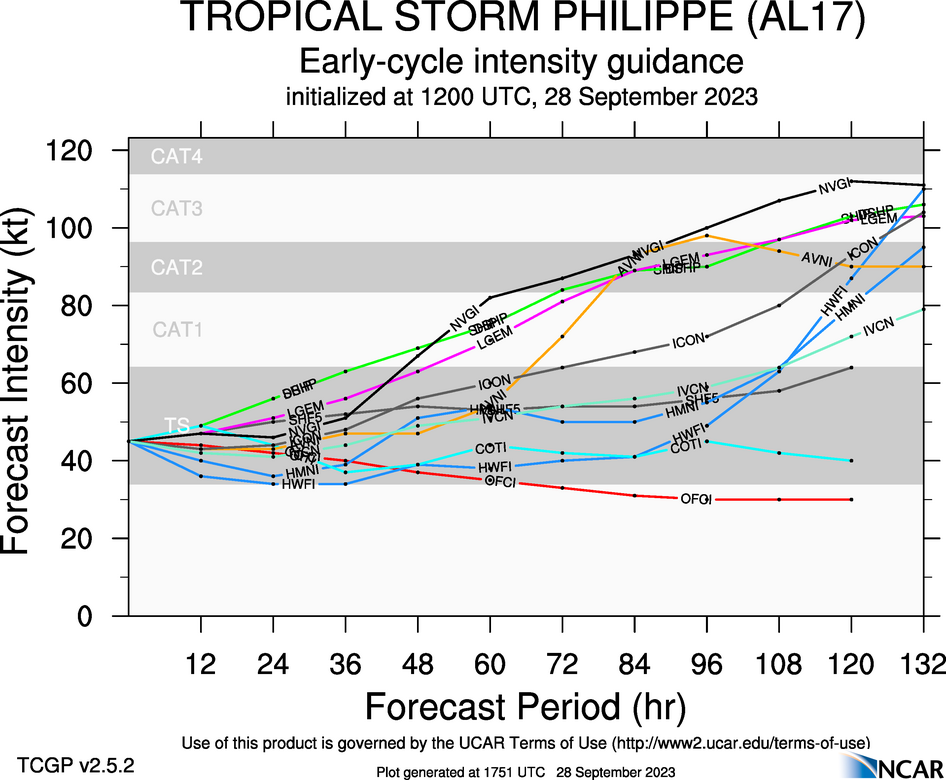
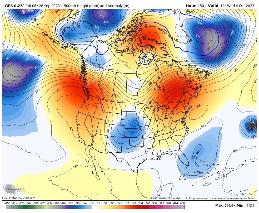
For PHILIPPE: The initial motion is highly uncertain since the storm is elongated and confidence in the initial position is very low. The track forecast is challenging, in part due to Philippe’s close proximity to newly formed Tropical Storm Rina. In the short term, a slow southwestward motion seems likely as Philippe moves in weak steering currents between a mid- to upper-level trough to its northeast and Rina to its east-southeast. By late in the weekend, a mid-level ridge is anticipated to build over the subtropical central Atlantic, and that feature should cause Philippe to turn sharply northward east of the northern Leeward Islands. The NHC track forecast has been adjusted to the south for the first couple of days, but lies to the east of the previous forecast at days 4 and 5. This prediction is closest to the ECMWF model. The environmental conditions for Philippe no longer seem unfavorable given its expected to track to the east of the islands and not within a region of strong shear. Therefore, the NHC intensity forecast has been adjusted upward and generally shows little change in strength during the next several days. This prediction still lies near the low end of the model guidance, however, so future advisories might show a higher intensity forecast if the guidance persists.
RINA: Rina is moving north-northwestward, with an initial forward speed near 9 kt. The tropical storm should begin to turn more westward today and continue this general motion for the next several days. Early next week, the system is expected to turn northward as a mid-level ridge builds to the west. The NHC forecast is a blend of the HCCA and TVCN consensus guidance throughout the forecast period. Confidence in the track forecast is lower than normal based on the model spread and uncertainty regarding the potential interaction with Tropical Storm Philippe during the next several days.
One very notable item which somewhat contradicts the intensity forecast on both storms is, the GFS and ECMWF both have the solution of the systems moving pretty much in line with the forecast tracks and guidance, however given the noted large area both are in, the models show the expansion of PHILIPPE and RINA becoming weaker and being absorbed by PHILIPPE. In fact, recent intensity guidance shows almost the opposite for each storm.


So, based on the uncertainties, until I can see what may actually play out, I have no choice but to go by the NHC intensity forecasts model guidance and forecast steering analysis.
12Z GUIDANCE AND NHC FORECAST TRACK


I’ll continue to monitor PHILIPPE for any significant or further changes to the forecast.
As of 11:00 a.m. EDT, the following information was available on newly developed Tropical Storm RINA from the NHC.
11:00 AM AST Thu Sep 28
Location: 17.4°N 45.0°W
Moving: NNW at 10 mph
Min pressure: 1005 mb / 29.68 in
Max sustained: 40 mph
Ok. Here we go again. Based on satellite imagery, NHC just named another naked swirl. So, once again by their criteria, they should not have designated this. Gotta get them numbers in.
![]()


