ALL forecasts herein are the result of my analysis, (to which you will see me at times, insert excerpts from various agencies due to the nature of the importance of the information) and I am solely responsible for the content. As ALWAYS, follow the National Hurricane Center, National Weather Service, and your local Emergency Management officials for emergency decisions. In addition, this is strictly a FORECAST OFFICE. I CANNOT make decisions regarding travel plans, etc. My purpose, is to provide you the information, based solely on information I analyze, and the accuracy of the information at hand of the time of analysis, so you may make informed decisions.
(T. F. “Storm” Walsh)
For those who have donated to my site, your help has been greatly appreciated. If you are not aware, donations to my site help pay for subscriptions to sites I use as well as software updates, which provide all the models and information used in my forecasts. To donate, please click the DONATE button to the right side of the page, or on the graphic of the dog. Any help you provide is immensely appreciated!
DONATIONS ACCEPTED AND APPRECIATED


If any of my subscribers here are on Facebook, and are in any of the weather groups I posted in, please let everyone know that Facebook suspended my old account. Since I may not be able to access Facebook anymore, you may follow me on twitter. The twitter button on the left of the page does not work. Please follow me here: https://twitter.com/Michael1227910
If you wish to become an email client and receive my forecasts by email, please send me an email at the email address at the bottom of the page…subject: EMAIL CLIENT.
I will reiterate, my forecasts are based on the available information at the time of analysis, and are only as accurate as the information analyzed and the solutions provided. Keep in mind, if a forecast doesn’t exactly pan out, remember, the atmosphere is fluid in motion. When models are being analyzed, that’s just one run, and I have to go with what is presented. After that, models don’t update again for another 4 – 6 hours, so, what happens between that time is unknown, and forecast conditions can change slightly, to greatly. This will have an effect on my actual forecast. Unless otherwise noted, satellite imagery is provided through Weathernerds.org
The following is my outlook forecast for the 2023 Atlantic Hurricane Season:
STORM W SEASONAL FORECAST
TOTAL NAMED STORMS: 14– 16
TOTAL HURRICANES : 5 – 7
MAJOR HURRICANES: 3 – 4
AVERAGE HURRICANE SEASON:
TOTAL NAMED STORMS: 14
TOTAL HURRICANES: 7
MAJOR HURRICANES: 3
SEASON TOTALS:
NAMED STORMS: 16
HURRICANES: 6
MAJOR HURRICANES: 3
Given that the NHC has named at least 3, if not more, garbage systems, I had to increase my seasonal forecast slightly.
The following are the storm names for the 2023 hurricane season. As each storm is named, they will be colored in red in order to keep track of the used names in the list:
Arlene Bret Cindy Don Emily Franklin Gert Harold Idalia Jose Katia
Lee Margot Nigel Ophelia Philippe Rina Sean Tammy Vince Whitney
Greetings everyone!
As a reminder, when forecasting tropical systems, if there are numerous systems to deal with, I always update on the systems that may present an impact or threat to either the U. S. or the Caribbean islands. Anything far out in the Atlantic or something that may re-curve, take a lower priority as there is more time to deal with them. Unless we have a system threatening any area, the forecast office will be closed on the weekends.
I am going to continue to monitor the disturbed weather over Florida as it moves off the east coast of the state. At the moment, I don’t believe anything will become of it, but who knows, this has been a strange season.
 Satellite loop imagery this afternoon indicates the center of Tropical Storm PHILIPPE is beginning to become exposed once again due to wind shear. In earlier satellite loop imagery, a deep area of convection had built close to the center, with just a partial exposure to the west of the convection. Satellite loop imagery also shows INVEST 91L a little disorganized as well. Both systems are now being affected by the same shear pattern caused by a radial shear pattern situated to south of the convective canopy associated with PHILIPPE. Both systems are under a fairly good size 200 mb outflow pattern.
PHILIPPE AND 91L CIMSS WIND SHEAR AND UPPER LEVEL WINDS


In my years of forecasting, I do not believe I’ve encountered this before. Looking at this however, future intensity may be a little harder to forecast, since the systems are in such close proximity, in that one is most likely stifling the other. Based on analysis of forecast conditions for PHILIPPE, shear is still forecast to increase during the next few days, with drier air in the forecast up to the mid levels. This appears to be occurring now, as you’ll notice in the visible imagery, arc clouds are racing out from the system. You’ll see a large one in the imagery for 91L, racing out from the upper left of the frame.
PHILIPPE IR AND VISIBLE SATELLITE LOOP


INVEST 91L IR AND VISIBLE SATELLITE LOOP


As of 11:00 a.m. EDT, the following information was available on PHILIPPE from the NHC:
11:00 AM AST Wed Sep 27
Location: 17.5°N 53.1°W
Moving: W at 9 mph
Min pressure: 998 mb / 29.47 in
Max sustained: 50 mph
PHILIPPE has intensified slightly, and the central pressure has decreased. This is most likely due to the convection building almost over the LLC earlier. Based on the newest wind shear forecast maps (which have changed from yesterday afternoon), PHILIPPE is forecast to remain under some moderate shear. But as he approaches the islands around late Thursday / early Friday, the shear and upper pattern could improve and convection could persist near the center, which could allow for now, a slower weakening trend. Depending on just how exactly the shear intensity plays out from now, there could be slight fluctuations in intensity. The storm is still forecast to move into an environment where mid level RH will be lower, and this could affect the convection. So, we could continue to see pulsing occur. For now, until I see how everything plays out, I agree with the NHC intensity forecast:
NHC INTENSITY FORECAST
INIT  27/1500Z 17.5N  53.7W   45 KT  50 MPH
 12H  28/0000Z 18.0N  54.7W   45 KT  50 MPH
 24H  28/1200Z 18.6N  56.1W   45 KT  50 MPH
 36H  29/0000Z 19.0N  57.8W   40 KT  45 MPH
 48H  29/1200Z 19.0N  59.5W   40 KT  45 MPH
 60H  30/0000Z 18.9N  60.8W   35 KT  40 MPH
 72H  30/1200Z 18.7N  62.2W   35 KT  40 MPH
 96H  01/1200Z 18.4N  64.7W   30 KT  35 MPH...POST-TROP/REMNT LOW
120H  02/1200Z 18.1N  66.9W   30 KT  35 MPH...POST-TROP/REMNT LOW
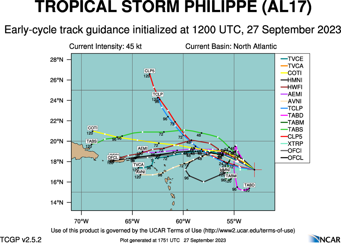
PHILIPPE continues on a westerly motion, and based on analysis of forecast steering maps and 500 mb geopotential heights, I expect this motion to continue during the next 48 hours. As he weakens toward depression status, a shift toward the WSW may occur, as the system will then be steered by the low level mean. The new track shows this coming into Puerto Rico now, and should increase precipitation for the island, and the northern Leeward islands chain. Based on this analysis, I agree with current consensus guidance and the NHC forecast track
12Z GUIDANCE

NHC FORECAST TRACK

ECMWF 7 DAY RAINFALL FORECAST ( in mm)

GFS (inches)

I’ll continue to monitor PHILIPPE for any significant or further changes to the forecast.
As of 8:00 a.m. EDT, the following information was available on INVEST 91L from the ATCF:
8:00 AM AST Wed Sep 27
Location: 11.6°N 43.5°W
Moving: W at 16 mph
Min pressure: 1007 mb / 29.74 in
Max sustained: 35 mph
As stated, invest 91L appears somewhat disorganized, due to some slight shearing going on. Based on analysis of the forecast parameters, there hasn’t been much change in the forecast. The ECMWF and GFS tend to indicate wind shear will fluctuate during the next 72 hours or so, and if lower values are encountered during the period, 91L should become better organized. Based on my analysis however, I still believe this is going to be a slow and gradual process until PHILIPPE is out of the picture, as both are sharing any positive qualities in the current pattern. Again, as 91L begins to head north of the islands, the pattern is still forecast to become much more favorable. There is a discrepancy in timing of this between the ECMWF and GFS, where the ECMWF shows a more favorable pattern by the 5th of October, and the GFS by the 3rd. Based on analysis of current track guidance, to which the GFS is following right now, I believe we should see 91L begin to intensify more by 144 hours, however I prefer the strength of the forecast pattern as presented by the ECMWF:
PWAT

500 MB RH

SHEAR PATTERN
![]()


 Satellite loop imagery this afternoon indicates the center of Tropical Storm PHILIPPE is beginning to become exposed once again due to wind shear. In earlier satellite loop imagery, a deep area of convection had built close to the center, with just a partial exposure to the west of the convection. Satellite loop imagery also shows INVEST 91L a little disorganized as well. Both systems are now being affected by the same shear pattern caused by a radial shear pattern situated to south of the convective canopy associated with PHILIPPE. Both systems are under a fairly good size 200 mb outflow pattern.


