Disclaimer: This site is not affiliated with the National Hurricane Center, Hurricane Hunters, Storm Prediction Center, or National Weather Service. ALL forecasts herein are the result of my analysis, (to which you will see me at times, insert excerpts from various agencies due to the nature of the importance of the information) and I am solely responsible for the content. As ALWAYS, follow the National Hurricane Center, National Weather Service, and your local Emergency Management officials for emergency decisions. In addition, this is strictly a FORECAST OFFICE. I CANNOT make decisions regarding travel plans, etc. My purpose, is to provide you the information, based solely on information I analyze, and the accuracy of the information at hand of the time of analysis, so you may make informed decisions.
(T. F. “Storm” Walsh)
For those who have donated to my site, your help has been greatly appreciated. If you are not aware, donations to my site help pay for subscriptions to sites I use as well as software updates, which provide all the models and information used in my forecasts. To donate, please click the DONATE button to the right side of the page, or on the graphic of the dog. Any help you provide is immensely appreciated!
DONATIONS ACCEPTED AND APPRECIATED


I will reiterate, my forecasts are based on the available information at the time of analysis, and are only as accurate as the information analyzed and the solutions provided.
Good evening everyone!
This is the final tutorial, and addresses tornado formation.
First, I wanted to start with an explanation of the term “cap” which I’m sure most of you are familiar with hearing this term. This term is short for “capping inversion. A “capping” inversion, or inversion, is where generally, in the mid to just below the mid atmosphere, air is warmer than the layer of air below it…or where the ELR (Environmental Lapse Rate) reverses and is warmer. Normally, as you go higher in the atmosphere, the surrounding environment grows colder. When a “cap”occurs, convection cannot grow or rise any further in the atmosphere once it encounters the level of the inversion. For thunderstorms to occur, convection has to continue to rise into the upper atmosphere, and the “cap” prevents this. When this happens, energy continues to “pile up” from the surface, to where the “cap” is located. The “average” ELR is approximately 6.49 ºC/km (3.56 °F or 1.98 °C/1,000 ft) from sea level to 11 km (or 6.8 mi). The average DAR (Dry Adiabatic Rate), or lapse rate of dry air (no condensation) is 9.8 °C/km or 5.5F /1,000 ft. When these averages are present, the atmosphere is considered stable. However, in my forecasts, you’ll see me mention mid level lapse rates. For instance, the lapse rates in one of my forecasts, where projected to be 7.5 to 8.0 Deg C. This is considered to be a conditionally unstable lapse. Lapse rates of 9.8 C km -1 are considered absolutely unstable, and are very steep, which allows air to rise almost violently until it reaches the condensation level. The following graphic shows a simple explanation of an inversion or “cap”:

Here is an excellent article from Meteorologist Jeff Haby (authored by Todd Wilson) on the “cap”:http://www.theweatherprediction.com/weatherpapers/070/index.html
There are two distinct ways to break this cap. This is from Jeff’s article:
There are several ways, however, to erode the cap. This can best be illustrated by using a Skew-T chart. The first is with daytime heating. An air parcel will rise adiabatically from the surface if the air parcel temperature on a sounding is warmer than the surrounding environmental air. In the case of the elevated mixed layer, the environmental temperature will be warmer than the temperature of the air parcel. As the heating of the day occurs, the air parcel temperature will begin to rise. If it raises enough to surpass the environmental temperature, then the air parcel will be free to rise on its own.
Another way is synoptic scale forcing or lifting. This situation does not have to rely on surface thermal heating. If a mechanism, such as a front, should come through, lifting of the air can be forced up to where it will help erode the capping inversion. Temperature changes in the vertical and mesoscale features can also aid in the erosion of the cap.
As this occurs, the warm, moist air and energy that has been trapped shoots up through he atmosphere violently, which can lead to very severe to violent thunderstorm activity, including strong tornadoes.
You have probably heard the old, simple explanation for tornado formation is, “when warm air and cold air collide, tornadoes form” This is true to an extent, however there is much more that goes on in the various levels of the atmosphere that is a little more complex, than just hot and cold air mixing. In my studies, it is noted that scientists are still not completely sure what causes a funnel to drop from a supercell, however I am going to try and give you some of the “ingredients” and try to explain some of the “workings”.
To start, yes, you need the mix of warm or hot, humid air, which is usually drawn in from the south by high pressure, off the Gulf of Mexico, and cold, drier air from the northern regions, usually originating from Canada or the Arctic, usually brought down by an area of low pressure. Two types of air come from here…cP (Continental Polar) or cA (Continental Arctic). The low pressure area we see on weather maps “mixes” everything together, and is natures way of trying to reach “equilibrium” in temperature and pressure differences. Sometimes, these differences can be extreme, so nature tries to achieve the balance quicker over a smaller area. This is what the job of the tornado is.
Favorable conditions for tornado formation include high dewpoints (60F>), a steep lapse rate, a certain amount of wind shear (both speed and directional), helicity in the atmosphere, high humidity, etc. These are not all of the factors, but you kind of get the idea.
The following composite maps are from a forecast back in 1948, when two tornadoes hit 5 days apart at Tinker Air Force Base in OK. The symbols on the maps are explained briefly, as to what they represent:
 Composite charts constructed for (a) 0600 UTC 21 Mar 1948 and (b) 0000 UTC 26 Mar 1948. Features are as on preceding charts with 500-mb features in blue, 850-mb features in red and green, with surface frontal analyses and 60°F dewpoint in black. The wavy green lines indicate moisture axes at 850 mb and the red dotted lines the axes of highest temperatures at 850 mb. Maximum observed wind speeds are indicated; many winds were missing at 500 mb.
With the great temperature differences at various levels of the atmosphere, we get the development of “jets”, or jet streams (A jet stream forms high in the upper troposphere between two air masses of very different temperature. The greater the temperature difference between the air masses, the faster the wind blows in the jet stream). You’ll notice the two different “jets” in the composite above, the 500 mb depicted in blue, and the 850 mb in red. You will sometimes hear of a LLJ (Low Level jet), this refers to the 850 mb level jet created when severe weather conditions come together. And, if you notice their direction, you can kind of see what would cause rotation or “spin’ in the atmosphere.
When these conditions are present, along with some other factors or “indices”, supercell thunderstorms can develop. These usually occur near a cold front, in the “warm sector” of the advancing weather system. The warm sector is the area between the warm front and cold front of the surface cyclone.
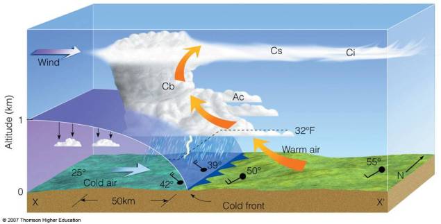
The cold front is what forces (lifts) the warm, moist air upward. The colder is much heavier or “dense” and the slope of the front is steeper:

Important cloud, wind, and temperature changes are revealed in this cross-section view of a typical cold front. The front rises steeply (1km rise across a 50km distance) and high clouds protrude ahead. The slope is also dependent on the speed of the front as well, therefore the fast the front, the steeper the slope which leads to greater upward vertical motion along the cold front. Slow moving cold fronts are associated with broader cloud and precipitation coverage behind the front. Fast moving cold fronts may send a fast moving squall line of showers ahead of the front.
Wind shear is an important factor also, in the development of tornadoes. Here is a decent video explaining how shear aids in tornado development:
https://youtu.be/E8KF0z0ey4E
SUPERCELL THUNDERSTORMS AND MESOCYCLONES
The following are two decent articles explaining what supercell thunderstorms and mesocyclones are:
SUPERCELL THUNDERSTORM:
https://en.wikipedia.org/wiki/Supercell
MESOCYCLONE:
https://en.wikipedia.org/wiki/Mesocyclone
The following video shows a Supercell/Mesocyclone in action:
https://youtu.be/o4KpudIF874
THE DRYLINE:
Most of the very severe weather and tornadic activity may occur in supercells along what is called the dryline. The dryline separates warm moist air to the east, from hot, dry air to the west. Hot, dry air is more dense than moist warm air, thus the warm moist air is forced to rise. Here is a video and short explanation regarding the dryline from the Weather Channel: https://weather.com/science/weather-explainers/news/dryline-severe-weather-tornado-storms-plains
Finally, the following article is from Meteorologist Jeff Haby regarding the dryline:
http://www.theweatherprediction.com/habyhints3/795/
The dryline depicted on a weather map:

In my research, I came across a decent article from the Markowski Research Group
in the Department of Meteorology & Atmospheric Science at Penn State University. The article is from Markowski and Richardson. Please take the time to read this…it is a very good article, at least from my perspective:
HOW TORNADOES FORM (LINK)
https://sites.psu.edu/pmarkowski/how-tornadoes-form/
The following explains some of the indices you hear me mention in my severe weather forecasts:
ENVIRONMENTAL PARAMETERS AND INDICES FROM NWS LOUISVILLE, KY.:
https://www.weather.gov/lmk/indices
Hurricanes can also spawn tornadoes upon landfall. These are formed differently than the tornadoes we encounter in the Midwest and Tornado Alley. Tornadoes in a hurricane are usually located in the right front quadrant of the hurricane, and develop from wind shear (mostly speed shear) and sometimes directional shear. This occurs as friction from the surface up to around 2,000 ft is greater upon landfall than over the ocean. This friction slows the speed of the wind from the surface to about 2,000 ft. This creates the turning, or “twisting” in the atmosphere necessary for tornadoes. Generally, these tornadoes are usually of EF0 – EF1 strength.
You may direct any questions by contacting me personally, ANYTIME, at: twalsh22000@yahoo.com
Have a blessed evening!
T. F. “STORM” WALSH III
GMCS, USCG (ret)
METEOROLOGIST / HURRICANE SPECIALIST /SEVERE WEATHER SPECIALIST
MEMBER WEST CENTRAL FLORIDA AMS


 Composite charts constructed for (a) 0600 UTC 21 Mar 1948 and (b) 0000 UTC 26 Mar 1948. Features are as on preceding charts with 500-mb features in blue, 850-mb features in red and green, with surface frontal analyses and 60°F dewpoint in black. The wavy green lines indicate moisture axes at 850 mb and the red dotted lines the axes of highest temperatures at 850 mb. Maximum observed wind speeds are indicated; many winds were missing at 500 mb.


