Notifications
ALL BUSINESS
COMIDA
DIRECTORIES
ENTERTAINMENT
FINER THINGS
HEALTH
MARKETPLACE
MEMBER's ONLY
MONEY MATTER$
MOTIVATIONAL
NEWS & WEATHER
TECHNOLOGIA
TV NETWORKS
VIDEOS
VOTE USA 2026/2028
INVESTOR RELATIONS
COMING 2026 / 2027
ALL BUSINESS
COMIDA
DIRECTORIES
ENTERTAINMENT
FINER THINGS
HEALTH
MARKETPLACE
MEMBER's ONLY
MONEY MATTER$
MOTIVATIONAL
NEWS & WEATHER
TECHNOLOGIA
TV NETWORKS
VIDEOS
VOTE USA 2026/2028
INVESTOR RELATIONS
COMING 2026 / 2027
About Me
 Latinos Media
 Latinos Media provides all types of news feeds on a daily basis to our Members
Posted by - Latinos Media -
on - September 23, 2023 -
Filed in - Weather -
-
0.9K Views - 0 Comments - 0 Likes - 0 Reviews

ALL forecasts herein are the result of my analysis, (to which you will see me at times, insert excerpts from various agencies due to the nature of the importance of the information) and I am solely responsible for the content. As ALWAYS, follow the National Hurricane Center, National Weather Service, and your local Emergency Management officials for emergency decisions. In addition, this is strictly a FORECAST OFFICE. I CANNOT make decisions regarding travel plans, etc. My purpose, is to provide you the information, based solely on information I analyze, and the accuracy of the information at hand of the time of analysis, so you may make informed decisions.
(T. F. “Storm” Walsh)
For those who have donated to my site, your help has been greatly appreciated. If you are not aware, donations to my site help pay for subscriptions to sites I use as well as software updates, which provide all the models and information used in my forecasts. To donate, please click the DONATE button to the right side of the page, or on the graphic of the dog. Any help you provide is immensely appreciated!
DONATIONS ACCEPTED AND APPRECIATED


If any of my subscribers here are on Facebook, and are in any of the weather groups I posted in, please let everyone know that Facebook suspended my old account. Since I may not be able to access Facebook anymore, you may follow me on twitter. The twitter button on the left of the page does not work. Please follow me here: https://twitter.com/Michael1227910
If you wish to become an email client and receive my forecasts by email, please send me an email at the email address at the bottom of the page…subject: EMAIL CLIENT.
I will reiterate, my forecasts are based on the available information at the time of analysis, and are only as accurate as the information analyzed and the solutions provided. Keep in mind, if a forecast doesn’t exactly pan out, remember, the atmosphere is fluid in motion. When models are being analyzed, that’s just one run, and I have to go with what is presented. After that, models don’t update again for another 4 – 6 hours, so, what happens between that time is unknown, and forecast conditions can change slightly, to greatly. This will have an effect on my actual forecast.
The following is my outlook forecast for the 2023 Atlantic Hurricane Season:
STORM W SEASONAL FORECAST
TOTAL NAMED STORMS: 14– 16
TOTAL HURRICANES : 5 – 7
MAJOR HURRICANES: 3 – 4
AVERAGE HURRICANE SEASON:
TOTAL NAMED STORMS: 14
TOTAL HURRICANES: 7
MAJOR HURRICANES: 3
SEASON TOTALS:
NAMED STORMS: 14
HURRICANES: 6
MAJOR HURRICANES: 3
SUB-TROPICAL STORMS:
Given that the NHC has named at least 3, if not more, garbage systems, I had to increase my seasonal forecast slightly.
The following are the storm names for the 2023 hurricane season. As each storm is named, they will be colored in red in order to keep track of the used names in the list:
Arlene Bret Cindy Don Emily Franklin Gert Harold Idalia Jose Katia
Lee Margot Nigel Ophelia Philippe Rina Sean Tammy Vince Whitney
Greetings everyone!
As a reminder, when forecasting tropical systems, if there are numerous systems to deal with, I always update on the systems that may present an impact or threat to either the U. S. or the Caribbean islands. Anything far out in the Atlantic or something that may re-curve, take a lower priority as there is more time to deal with them. Unless we have a system threatening any area, the forecast office will be closed on the weekends.
I will not be updating on INVEST 90L in the Atlantic, until PTC 16 makes landfall.
PTC 16 may be transitioning to a sub-tropical cyclone. As of 8:00 a.m. EDT, the following information was available on PTC 16 from the NHC:
8:00 AM EDT Thu Sep 21
Location: 31.3°N 75.3°W
Moving: N at 14 mph
Min pressure: 996 mb/29.41 in
Max sustained: 50 mph
Satellite loop imagery indicates the LLC is displaced just south of the convective area. However, in last couple of frames of the loop, it appears there may be a center reformation occurring toward the deep convection.
WEATHERNERDS PTC 16 SATELLITE LOOP IMAGERY

Analysis of visible imagery seems to indicate some very slight dry air intrusion, based on the presence of various arc cloud formations. While the PTC remains under shear and a baroclinic environment, analysis did indicate shear has relaxed directly over and somewhat SE of the LLC. This may be allowing for the LLC to reform toward the heavy convection. It is also noted in the recent PWAT image that the circulation appears to be tightening somewhat with a slight increase in precipitable water, with an inner core possibly trying to develop.
CIMSS WIND SHEAR AND UPPER LEVEL WINDS

PWAT
CIMSS SHEAR TENDENCY
Based on the forecast however, wind shear, limited moisture, and the zonal 200 mb level forecast, PTC 16 will continue deriving it’s energy from baroclinic processes as the aforementioned conditions are forecast to persist to approximately 6 – 8 hours prior to landfall. Thereafter, both global models ECMWF and GFS indicate a change to the shear pattern, showing the beginning of a radial pattern materializing. Based on this new information in the modeling, should the trend of lessening shear continue and the system sheds the front it’s attached to, PTC 16 could transition to sub-tropical late today, and could become tropical just before landfall. The following from NOAA explains briefly each process:
Baroclinic Zone
A region in which a temperature gradient exists on a constant pressure surface. Baroclinic zones are favored areas for strengthening and weakening systems; barotropic systems, on the other hand, do not exhibit significant changes in intensity. Also, wind shear is characteristic of a baroclinic zone.
Barotropic System
A weather system in which temperature and pressure surfaces are coincident, i.e., temperature is uniform (no temperature gradient) on a constant pressure surface. Barotropic systems are characterized by a lack of wind shear, and thus are generally unfavorable areas for severe thunderstorm development. See baroclinic zone.
Based on my analysis of the various forecast parameters, I believe rapid feedback will continue prior to landfall. Though I agree pretty much with the NHC intensity forecast, I feel PTC 16 could intensify more toward 70 mph
NHC INTENSITY FORECAST
INIT 22/0900Z 30.5N 75.0W 45 KT 50 MPH…POTENTIAL TROP CYCLONE
12H 22/1800Z 31.6N 75.8W 50 KT 60 MPH…TROPICAL CYCLONE
24H 23/0600Z 33.4N 76.5W 50 KT 60 MPH
36H 23/1800Z 35.3N 76.8W 45 KT 50 MPH…INLAND
48H 24/0600Z 37.0N 76.9W 35 KT 40 MPH…INLAND
60H 24/1800Z 38.3N 76.3W 30 KT 35 MPH…POST-TROP/EXTRATROP
72H 25/0600Z 39.0N 75.2W 30 KT 35 MPH…POST-TROP/EXTRATROP
96H 26/0600Z…DISSIPATED
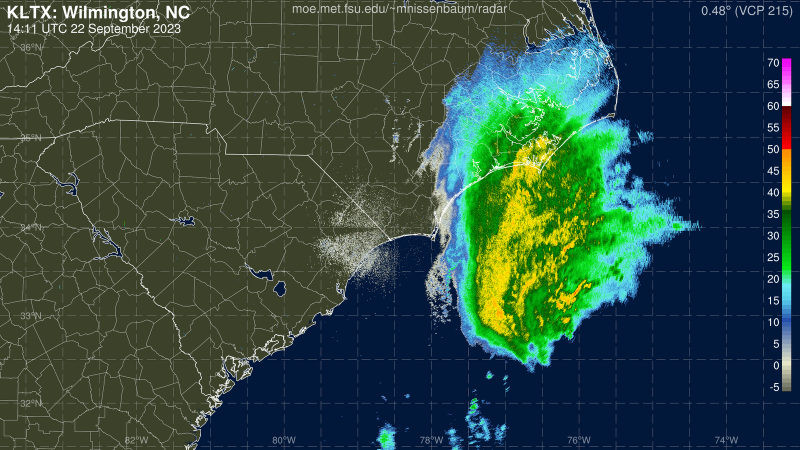
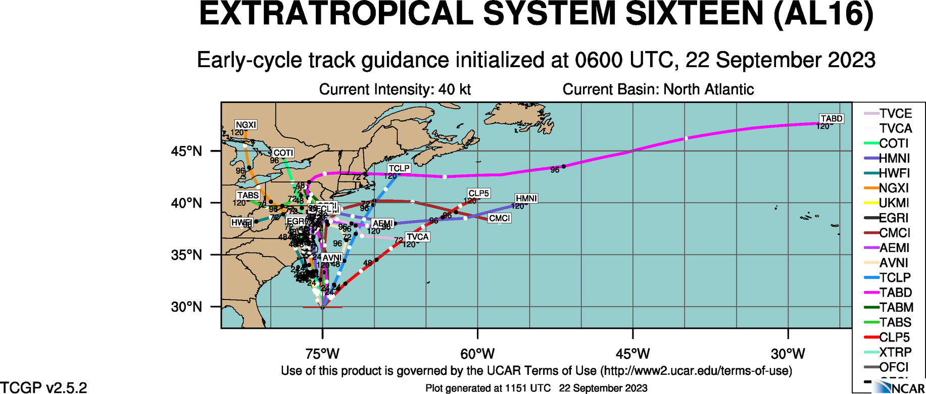
The system was moving toward the north, and based on my analysis of forecast steering layers, MSLP anomaly animations, and 500 mb geopotential height forecasts, I expect this general motion to continue briefly, when a track more to the NNW is expected as a deep layer trof finally picks up the storm, and draws it in to the coast. Based on this, I agree with the current guidance package and NHC forecast track. Based on this, I expect landfall at the moment to occur near Beaufort, NC.
06Z ATCF GUIDANCE
NHC FORECAST TRACK
Very high waves are forecast along the coast, and residents should be prepared for coastal flooding, minor beach erosion, and storm surge along with rip currents. Residents are advised to remain away from the shoreline during this storm. The following are the MSLP anomaly forecast, projected surface winds, rainfall and wave forecasts:


