Notifications
ALL BUSINESS
COMIDA
DIRECTORIES
ENTERTAINMENT
FINER THINGS
HEALTH
MARKETPLACE
MEMBER's ONLY
MONEY MATTER$
MOTIVATIONAL
NEWS & WEATHER
TECHNOLOGIA
TV NETWORKS
VIDEOS
VOTE USA 2026/2028
INVESTOR RELATIONS
DEV FOR 2025 / 2026
ALL BUSINESS
COMIDA
DIRECTORIES
ENTERTAINMENT
FINER THINGS
HEALTH
MARKETPLACE
MEMBER's ONLY
MONEY MATTER$
MOTIVATIONAL
NEWS & WEATHER
TECHNOLOGIA
TV NETWORKS
VIDEOS
VOTE USA 2026/2028
INVESTOR RELATIONS
DEV FOR 2025 / 2026
About Me
 Latinos Media
 Latinos Media provides all types of news feeds on a daily basis to our Members
Posted by - Latinos Media -
on - September 15, 2023 -
Filed in - Weather -
-
543 Views - 0 Comments - 0 Likes - 0 Reviews

ALL forecasts herein are the result of my analysis, (to which you will see me at times, insert excerpts from various agencies due to the nature of the importance of the information) and I am solely responsible for the content. As ALWAYS, follow the National Hurricane Center, National Weather Service, and your local Emergency Management officials for emergency decisions. In addition, this is strictly a FORECAST OFFICE. I CANNOT make decisions regarding travel plans, etc. My purpose, is to provide you the information, based solely on information I analyze, and the accuracy of the information at hand of the time of analysis, so you may make informed decisions.
(T. F. “Storm” Walsh)
For those who have donated to my site, your help has been greatly appreciated. If you are not aware, donations to my site help pay for subscriptions to sites I use as well as software updates, which provide all the models and information used in my forecasts. To donate, please click the DONATE button to the right side of the page, or on the graphic of the dog. Any help you provide is immensely appreciated!
DONATIONS ACCEPTED AND APPRECIATED


If any of my subscribers here are on Facebook, and are in any of the weather groups I posted in, please let everyone know that Facebook suspended my old account. Since I may not be able to access Facebook anymore, you may follow me on twitter. The twitter button on the left of the page does not work. Please follow me here: https://twitter.com/Michael1227910
If you wish to become an email client and receive my forecasts by email, please send me an email at the email address at the bottom of the page…subject: EMAIL CLIENT.
I will reiterate, my forecasts are based on the available information at the time of analysis, and are only as accurate as the information analyzed and the solutions provided. Keep in mind, if a forecast doesn’t exactly pan out, remember, the atmosphere is fluid in motion. When models are being analyzed, that’s just one run, and I have to go with what is presented. After that, models don’t update again for another 4 – 6 hours, so, what happens between that time is unknown, and forecast conditions can change slightly, to greatly. This will have an effect on my actual forecast.
The following is my outlook forecast for the 2023 Atlantic Hurricane Season:
STORM W SEASONAL FORECAST
TOTAL NAMED STORMS: 14– 16
TOTAL HURRICANES : 5 – 7
MAJOR HURRICANES: 3 – 4
AVERAGE HURRICANE SEASON:
TOTAL NAMED STORMS: 14
TOTAL HURRICANES: 7
MAJOR HURRICANES: 3
SEASON TOTALS:
NAMED STORMS: 13
HURRICANES: 5
MAJOR HURRICANES: 3
Given that the NHC has named at least 3, if not more, garbage systems, I had to increase my seasonal forecast slightly.
The following are the storm names for the 2023 hurricane season. As each storm is named, they will be colored in red in order to keep track of the used names in the list:
Arlene Bret Cindy Don Emily Franklin Gert Harold Idalia Jose Katia
Lee Margot Nigel Ophelia Philippe Rina Sean Tammy Vince Whitney
Greetings everyone!
As a reminder, when forecasting tropical systems, if there are numerous systems to deal with, I always update on the systems that may present an impact or threat to either the U. S. or the Caribbean islands. Anything far out in the Atlantic or something that may re-curve, take a lower priority as there is more time to deal with them.
Hurricane LEE is now a Category 1 hurricane. As of the 2:00 p.m. EDT advisory from the NHC, the following was available on LEE:
2:00 PM AST Thu Sep 14
Location: 31.0°N 68.4°W
Moving: N at 14 mph
Min pressure: 957 mb / 28.26 in
Max sustained: 85 mph
WEATHERNERDS GOES 16 HURRICANE LEE LOOP IMAGERY

LEE is now moving toward the N. Based on my analysis of the current and forecast steering pattern, LEE should continue this motion through today. On Friday, based on the forecast interaction of the ridge, and deep trof over the east, slight, breif bend toward the NNW could occur, before LEE is finally under the full influence of the trof, and continues to move in a NNE direction, entering the extreme eastern Gulf of Maine, and should make landfall just on the coast of western Nova Scotia. Analysis of the global models, indicate all of the global models have ceased the sharper left bend. Evidently, the models did not handle the pattern too well, having shown this leftward bend, which would have brought LEE into the central coast of Maine. As I’ve said, I can only make a forecast with what information is presented for me to analyze. Looking at current steering, the trof has dug further south, as opposed to previously forecast.
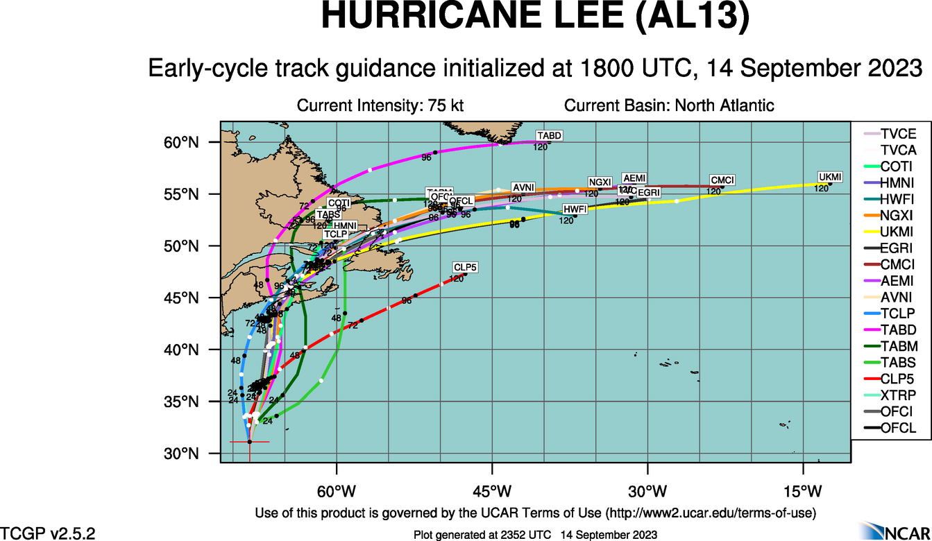
Given that modeling continues to shift slightly right this afternoon, I agree with with the current model track guidance, and NHC forecast track.
18Z ATCF TRACK GUIDANCE
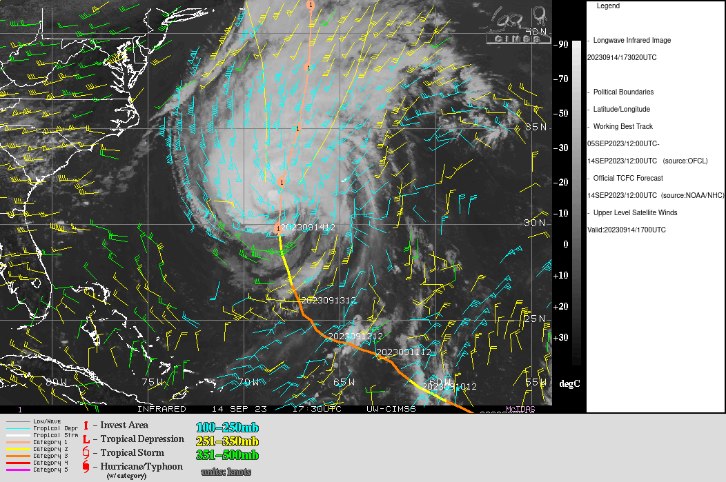
NHC FORECAST TRACK Analysis of the satellite of the satellite loop imagery did indicate the eye has filled, but a decent CDO still remained as of the most recent imagery. Wind shear has increased to around 25 – 30 kts and the upper level outflow pattern is still robust. Given the shear is flowing with the storm, and the upper level outflow is still robust, shear should not have too much effect on LEE. Wind shear is however forecast to increase rapidly to over 30 kts by later tomorrow. This, and a combination of colder waters, should allow LEE to continue the weakening trend, which will increase most likely after 48 hours.
CIMSS WIND SHEAR AND UPPER LEVEL WINDS

Based on this analysis, I agree with the NHC intensity forecast:
INIT 14/1500Z 30.4N 68.3W 80 KT 90 MPH
12H 15/0000Z 32.2N 68.0W 75 KT 85 MPH
24H 15/1200Z 35.0N 67.2W 70 KT 80 MPH
36H 16/0000Z 38.2N 66.6W 70 KT 80 MPH
48H 16/1200Z 41.5N 66.5W 65 KT 75 MPH
60H 17/0000Z 44.0N 66.1W 55 KT 65 MPH…POST-TROP/EXTRATROP
72H 17/1200Z 47.0N 63.6W 45 KT 50 MPH…POST-TROP/EXTRATROP
96H 18/1200Z 52.6N 52.2W 35 KT 40 MPH…POST-TROP/EXTRATROP
120H 19/1200Z…DISSIPATED
Please refer to the NHC Public Advisory link for watches, warnings, and hazards the affected areas:
NHC PUBLIC ADVISORY LINK:
https://www.nhc.noaa.gov/text/refresh/MIATCPAT3+shtml/141745.shtml?
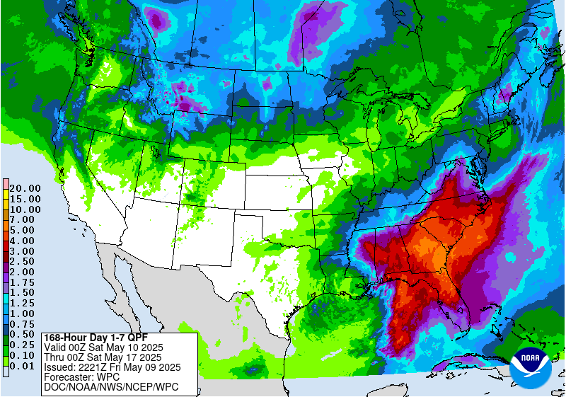
WPC 7 DAY RAINFALL TOTAL FORECAST
NHC PEAK STORM SURGE![[Image of cumulative wind history]](https://www.nhc.noaa.gov/storm_graphics/AT13/refresh/AL132023_peak_surge+png/150936_peak_surge.png)
![[Key Messages]](https://www.nhc.noaa.gov/storm_graphics/AT13/refresh/AL132023_key_messages+png/144019_key_messages_sm.png)
![[Spanish Key Messages]](https://www.nhc.noaa.gov/storm_graphics/AT13/refresh/AL132023_spanish_key_messages+png/144019_spanish_key_messages_sm.png)
The following link contains local hurricane products from your local NWS. Once on the page, click the bold blue under local impacts and local statement:
https://www.nhc.noaa.gov/text/refresh/index_hls3+shtml/141854.shtml?
NHC GRAPHICS PAGE
https://www.nhc.noaa.gov/refresh/graphics_at3+shtml/203849.shtml?3-daynl
ECMWF AND WAVEWATCH 3 WAVE HEIGHTS AND DIRECTION FORECAST


I will continue to monitor the progress of LEE for any significant changes that may occur to the forecast conditions, and will issued local products if and when they are issued by the NHC.
Elsewhere, I am going to begin to monitor INVEST 97L, and will be performing updates as soon as we are finished with LEE.