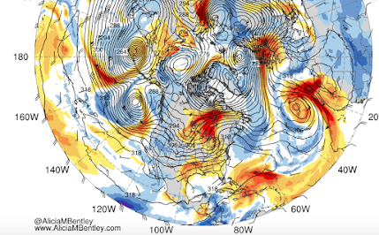
One of the most overused terms used by the media is "atmospheric river". Yes, even more hyped than "bomb cyclone." But this week there will be an atmospheric river worth noting...and I will discuss below.
Atmospheric River Overuse
Although the term, atmospheric river, was first used in the late 1990s, the phenomenon was well-known for decades before that: a plume of warm, moist air leading cold fronts associated with midlatitude cyclones.
Virtually every midlatitude cyclone/low center has such a plume of moist air. To see how omni-present atmospheric rivers are, below is map from today of the plumes of water vapor (red and orange colors) and heights at 700 hPa pressure (think of this as pressure at 10,000 ft). LOTS of atmospheric rivers, with most associated with low centers and their associated fronts.
But not all atmospheric rivers are equal in magnitude.
This week some particularly strong ones will aim at northern California and southern Oregon, releasing intense precipitation as the moisture-laden area is forced to rise by the regional terrain.
One of the best measures of atmospheric river strength is integrated water vapor transport (IVT), which is calculated by determine how much water vapor is being transported by the atmospheric river over a period of time (essentially wind speed times water vapor content of the air).
Here is a plot of IVT on Wednesday evening. WOW...that is quite an atmopsheric river!
The result or this atmospheric river and some weaken cousins this week, will be massive rainfall on the West Coast.
For the 72 h ending 4 PM Thursday, there will be massive precipitation totals predicted (by the UW model) from northern CA through BC, with northern CA/SW Oregon getting hit hardest (over 5 inches).
Here are the totals through the end of the year from the European Center model. Many locations will enjoy over a foot of rain.
Remember all the talk of permanent drought in CA during the global warming.
Well, such predictions have not worked out well.
Most California reservoirs are above normal right now....and that is before the big rains this week (see the proof below). Reservoir levels will surge with all the upcoming rain.
Snowpack is in good shape for the entire Wast Coast. (see below).
In short, water supply looks excellent for the upcoming year.


