Disclaimer: This is not affiliated with the National Hurricane Center, Hurricane Hunters, Storm Prediction Center, or National Weather Service. ALL forecasts herein are the result of my analysis, (to which you will see me at times, insert excerpts from various agencies due to the nature of the importance of the information) and I am solely responsible for the content. As ALWAYS, follow the National Hurricane Center, National Weather Service, and your local Emergency Management officials for emergency decisions. In addition, this is strictly a FORECAST OFFICE. I CANNOT make decisions regarding travel plans, etc. My purpose, is to provide you the information, based solely on information I analyze, and the accuracy of the information at hand of the time of analysis, so you may make informed decisions.
(T. F. “Storm” Walsh)
For those who have donated to my site, your help has been greatly appreciated. If you are not aware, donations to my site help pay for subscriptions to sites I use as well as software updates, which provide all the models and information used in my forecasts. To donate, please click the DONATE button to the right side of the page, or on the graphic of the dog. Any help you provide is immensely appreciated!
DONATIONS ACCEPTED AND APPRECIATED


The forecast office will be closed from Mar. 03 until further notice. My wife and I will be leaving for Alabama again, to visit my mom, who was recently diagnosed with stage 4 cancer.
I will reiterate, my forecasts are based on the available information at the time of analysis, and are only as accurate as the information analyzed and the solutions provided.
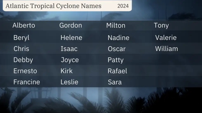
The following are storm names for the 2024 Atlantic Hurricane Season:

As I did last and past seasons, when I start issuing forecasts, I will have the names listed, and will highlight each in red, as the name becomes used.
The outlined maps you were used to seeing from my F5 DATA software, are no longer around and operational. This means I have lost quite a bit of data to analyze but I will try to make the severe weather forecasts as accurate and understandable as possible.

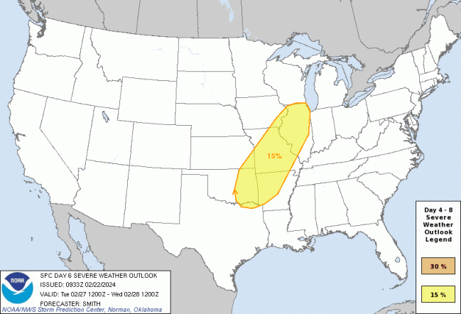
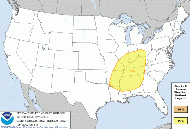
The Storm Prediction Center (SPC), has issued a 15% risk of severe thunderstorms in the day 6 / 7 outlook:
FOR THE CENTRAL GREAT PLAINS REGION ON DAY 6…FURTHER EAST ON DAY 7
…SPC SUMMARY…
Day 4-8 Convective Outlook
NWS Storm Prediction Center Norman OK
0333 AM CST Thu Feb 22 2024
Valid 251200Z – 011200Z
…DISCUSSION…
Medium-range models continue to show a powerful mid- to upper-level trough ejecting into the central U.S. by late Tuesday into Wednesday. A deep cyclone is currently progged by most ensemble members to move from the central Great Plains into the Great Lakes vicinity. Preceding this upper trough, an antecedent re-charging of steep lapse rates associated with an elevated mixed layer over the southern High Plains is forecast. A few days of airmass modification, both in terms of ambient temperature and moistening over the Gulf Basin, will occur in wake of frontal passage on Saturday. Northward moisture return beneath the aforementioned EML will probably result in a substantial warm sector by late afternoon Tuesday and into Wednesday farther east. Model run-to-run continuity is such that there is increased confidence in the introduction of 15-percent severe-risk highlights with the expected eastward progression of the trough. Will defer the possibility of an additional area farther east on Thursday until confidence in details related to earlier days becomes more focused.
SPC DAY 6 SEVERE THUNDERSTORM OUTLOOK MAP (LINKED…CLICK IMAGE)


SPC DAY 7 SEVERE THUNDERSTORM OUTLOOK MAP


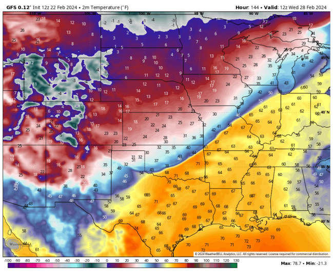
Based on my analysis of the current outlook, CIPS forecast model (using the GFS) and GFS model. Information was limited, and forecast parameters and indices will change numerous times as we get closer to the day 1 outlook. Once the NAM model comes within range, I will be utilizing it for the updates. As of analysis, most indices indicate the forecast of a marginally unstable atmosphere, although this can change. Things to note in this brief is SRH, deep layer shear, and steeper mid level lapse rates. Once again, veering winds will be an issue. Also, looking at forecast temperature maps, it appears a strong cold front will be responsible for the probable severe weather, as there is at least a 30F degree difference between the warmer air and colder air. The following were the forecast parameters and indices analyzed this morning. Indices meanings can be accessed further on in the synopsis:
SBCAPE: 250 – 750 j/kg-1
MLCAPE: 250 – 500 j/kg-1
MUCAPE: 250 – 500 j/kg-1
SRH 0 – 1km: 200 – 300 m2/s2
SRH 0 – 3km: 300 – 400 m2/s2
SRH EFFECTIVE: 100 – 300 m2/s2
L. I.: -1 to -3
STP: 1
SCP: 2 to 3
0 -6 km SHEAR: 50 – 60 kts
EFF. SHEAR: 40 – 50 kts
MID LEVEL LAPSE RATE: 7.5 – 8.5C
DEWPOINT: 56F – 61F
EHI: 0.7 – 1.0
TOTAL TOTALS INDEX: 45 – 51
K INDEX: 27 – 32
STP ( Significant Tornado Parameter) EXPLAINED:
A majority of significant tornadoes (EF2 or greater damage) have been associated with STP values greater than 1, while most non-tornadic supercells have been associated with values less than 1 in a large sample of RAP analysis proximity soundings.
SCP (Supercell Composite Parameter) EXPLAINED:
A multiple ingredient, composite index that includes effective storm-relative helicity (ESRH, based on Bunkers right supercell motion), most unstable parcel CAPE (muCAPE) and convective inhibition (muCIN), and effective bulk wind difference (EBWD). Each ingredient is normalized to supercell “threshold” values, and larger values of SCP denote greater “overlap” in the three supercell ingredients. Only positive values of SCP are displayed, which correspond to environments favoring right-moving (cyclonic) supercells.
The following is the GFS surface temperature forecast for 12Z Wednesday 28 FEB. Note the difference in temperatures:

The following sites will explain most of these values, and will give you an idea of what to expect:
ENVIRONMENTAL INDICES AND PARAMETERS NWS
https://www.weather.gov/lmk/indices
THE WEATHER PREDICTION
http://www.theweatherprediction.com/severe/indices/
SPC HOMEPAGE LINK
https://www.spc.noaa.gov/classic.html
The following NWS Watch / Warning map will provide local NWS information for your area. Click the image, then once it refreshes, click on your area of interest to view any special weather statements, hazards or advisories for your area.
NWS WATCH / WARNING DISPLAY (LINKED…CLICK MAP, THEN YOUR AREA)

NWS DOPPLER RADAR LOOP (LINKED, CLICK RADAR MAP)

RAP RADAR (CLICK IMAGE THEN GO TO LOOP DURATION AND PICK LENGTH OF LOOP, THEN CLICK RADAR SITE)
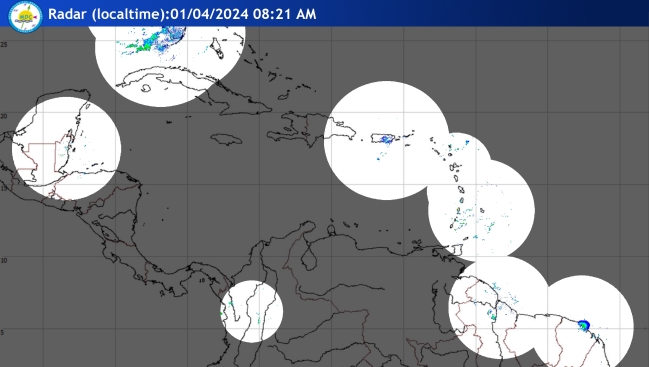
CARIBBEAN RADAR (CLICK IMAGE)

You may direct any questions by contacting me personally, ANYTIME, at: twalsh22000@yahoo.com
Have a blessed evening!
T. F. “STORM” WALSH III
GMCS, USCG (ret)
METEOROLOGIST / HURRICANE SPECIALIST /SEVERE WEATHER SPECIALIST


